

Guided Tongariro Alpine Crossing
The Tongariro National Park has Dual World Heritage status and includes The Tongariro Alpine Crossing and the Northern Circuit which are part of the Department of Conservation ‘Great Walks’ network. The three active andesitic volcanoes, Mt. Tongariro 1967m (6453 ft), Mt. Ngauruhoe 2291m (7516 ft) and Mt. Ruapehu 2797m (9176 ft), are majestic and dominate the National Park. The Tongariro area has grown over the last 300,000 years and was formed from many different eruptions from at least six cones. Intense volcanic activity and retreating glaciers from the ice age, have all left amazing textures, colours and landscapes with the many stories of fire and ice to tell.
The Itinerary
Mangatepopo to Soda Springs. Grade: Easy. Allow 1 hour - 1 1/2 hours
At the Mangatepopo carpark is a shelter and toilet facilities. This first section of the track is fairly flat. The track is well formed and board walked in damper parts. About 20 minutes from the car park is a sidetrack to the Mangatepopo Hut, and toilet facilities. The main track continues up the valley following the Mangatepopo stream and around the edge of old lava flows. It is interesting to notice the change in plants as you climb in altitude. At Soda Springs are the last toilet facilities until you get to the Ketetahi Hut.
Soda Springs to South Crater. Grade: Moderate Difficult. Allow 40 minutes to 1 hour
This section is steep - climbing from 1400m (4593 ft) up to 1600 metres (5249 ft) above sea level and is known as the devils staircase. Take your time - slow and steady is the best way to conquer this section. On a clear day the view down the valley and out across the surrounding countryside is well worth it! You may even see Mt. Taranaki, another volcano on the western horizon. Take care as you are walking over layers of ancient and modern lava flows and other volcanic debits so the track surface is not smooth.
South Crater to Red Crater. Grade: Moderate Difficult. Allow 1 hour
It is great to be on the flat, but once you have crossed South Crater there is another short climb on an exposed ridge. The track follows the ridge to Red Crater. If you have plenty of time you can make the decision to summit Tongariro. The main track continues around Red Crater. You have spectacular views over the Oturere Valley, Rangipo Desert, Kaimanawa Ranges and down to the Emerald Lakes.
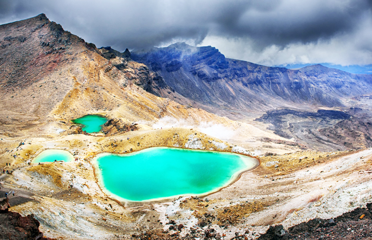
Red Crater to Blue Lake. Grade: Moderate. Allow 30 minutes
Care is required with the descent from Red Crater, as this part of the track is steep and you are on loose scoria which can move under foot. To the left you will see an old lava flow from Red Crater spreading out across the floor of The Tongariro Northern Circuit track to Otureree Hut branches off just past the lowest Emerald Lake. The Tongariro Crossing track follows around the edge of Central Crater then climbs up to Blue Lake (A cold acidic lake). The lake is tapu (sacred) and it is disrespectful to eat or drink around its shores/central crater. To the right are the Emerald Lakes. Minerals leached from the surrounding rock cause the brilliant emerald colour. The steam vents above the lake are responsible for the sulphurous smell.
Blue Lake to Ketetahi Hut. Grade: Moderate. Allow 1 hour
There is a short easy climb to the edge of North Crater. This crater was once filled with molten lava which then cooled and solidified giving a level surface more than 1000m (3280 ft) wide. In good weather there are spectacular views out over Mt. Pihanga and Lake Rotoaira to Lake Taupo. You then zigzag your way down to the Ketetahi Hut through the natural alpine garden. Ketetahi Hut has toilet facilities.
Ketetahi Hut to Ketetahi Carpark. Grade: Moderate. Allow 2 hours
The track crosses the stream that flows down from Keteahi Hot Springs and the rocks are stained interesting colours from the minerals in the water. The track leads through open tussock land to a clearing with some seats. At this point the track drops steeply to the Mangatetipua Stream and through native forest for about an hour and a half. There is a short sidetrack leading to a waterfall a few minutes before reaching the Ketetahi carpark. The Ketetahi carpark has a shelter, toilets and a refreshment from us
waiting for you.
!
Important Note
The problem with the Crossing...
It’s been declared the greatest one day walk in New Zealand – which is quite an honour since New Zealand is full of amazing hikes. However every day in summer, hundreds of people take to the crossing and every year people get lost and unfortunatly even die. This is a high altitude alpine environment and is very different from what many people are used to. A potential disaster is just a simple change in the weather away. It is essential that you are properly prepared to walk the Tongariro Alpine Crossing.
We say this purely to get your attention, so you stop and think. This is not just another attraction to turn up to and check of your bucket list - It requires some planning. Please read our Safety in New Zealand's Great Outdoors Article
Other Tongariro National Park Options
- Exclusive Tongariro Alpine Crossing Guided Walk
- Sunrise Tongariro Alpine Crossing Guided Walk
- Mt. Ruapehu Crater Lake Guided Walk
- Exclusive Mt. Ngauruhoe Guided Walk
** Please Note: We do not book this excursion as a stand-alone booking. However we can incorporate this into a New Zealand self-drive itinerary. This service is FREE and what's more, we can often save you money and time on planning your holiday – Find Out How

What Kasey says about this tour: I’m so glad I did this day hike with a guide as their knowledge made everything so much more interesting. A fantastic way to spend a day with magnificent views!
Enquire Now